This mailer has been provided as an avenue to disperse information pertinent to public agencies and the landscape architecture profession in hopes of fostering greater understanding and collaboration. Topics address issues that affect the built environment within which we live.
High Definition Laser Scans
"Fast is fine, but accuracy is everything.", Xenophon
Throughout the past decade, high definition laser scanning as a method of obtaining spatial data has grown in popularity. This type of scanning is widely utilized for design surveys, topographic mapping, and building information modeling (BIM) within the architectural, engineering and survey professions. Though most commonly used in these professions, other applications may also include construction, manufacturing, forensics, historic preservation and mining. The following synopsis of this technology will address technical aspects of laser scanning, product deliverable, scan accuracy and possible applications.
Technical background -
Laser scanners consist of three primary components; a laser beam, scanning mirrors and a camera. After a laser beam is directed toward an intended object or space, the equipment records spatial coordinates, laser intensities and project management data. As this data is combined and processed, the coordinate points form three dimensional models of spaces and objects. These systems are capable of collecting thousands of points per second resulting in databases containing tens of millions of points. Data point volumes of this magnitude are far too intense for standard CAD systems to handle, however, point cloud software is used to convert these databases into manageable files compatible with common CAD systems.
Product Deliverable -
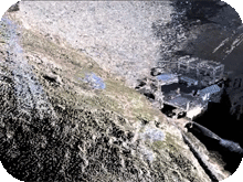
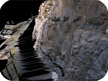
After scanned data has been completely processed and converted to compatible files, the points can be viewed in wire frame, point data or photo images. If desired, combinations of these images are also easily created. Examples of these images are shown in the right hand column of this narrative. In addition to simply viewing two-dimensional images of the data, these three-dimensional models can be explored and viewed from an infinite number of angles and perspectives. Simulated flyovers and walk-though animations can also be created and provide valuable information and insight into the project. O'Dell Engineering recently completed an application of this technology on the Exchequre Dam in Mariposa County, CA. Visit O'Dell Engineering's featured projects located at this link to see a short fly-through example of this project.
Accuracy -
Similar to other methods of obtaining spatial information, the accuracy of this technology varies depending on the application. Long range scanners used for general earthwork grading calculations or mining operations have ranges of over 2,000 feet and are accurate within a few inches. However, close range scanners used in smaller areas and tight spaces can achieve .01' accuracy (This may vary depending on site specific surface conditions)
Applications -
Laser Scanning is an excellent alternative to traditional methods where three-dimensional spatial data is required. Scanning becomes increasingly cost effective as the required level of detail increases and when accessibility to the site decreases. The benefits become apparent when an example comparison is drawn between the development of a BIM for a manufacturing plant using traditional survey methods versus scanning and obtaining thousands of data points per second. The savings can be significant. Scanning is also an excellent alternative when large spaces, dangerous conditions or traffic closures are concerns, as is frequently the case with large freeways and interstates highway projects. Projects located within rugged terrain may also be great candidates for this type of survey.
In just a few hours of scanning, a small commercial site or a building interior can be scanned, processed and 3d models can be created. These models can then be used throughout the design and construction phases of the project.
Conclusion -
High definition laser scanning is yet another great tool with great potential and with seemingly endless applications. Though this method of data gathering will not be appropriate nor feasible for every project, its versatility certainly opens the doors of opportunity for many projects out there. If you have any questions about this technology feel free to call us. One of O'Dell Engineering's survey staff would be happy to tell you more about it.
![]()
The next time you need a Landscape Architect on your project, consider O'Dell Engineering's Landscape Architecture Department.
Services include:
- Park and Playground Design
- Recreational Facility Design
- Site Planning
- Streetscape Design
- Urban Design
- Commercial Design
- 3-D Visualizations
- Graphic Design
- Arborist Consulting
![]()

Author: Chad Kennedy, Landscape Architect
This informational article provided by O'Dell Engineering - 1165 Scenic Drive, Suite A, Modesto CA 95350